You are here: Home
Dark Waters
The Dark Waters Project GroupFor more information about Dark Waters maps of London's buried tributaries, original written content, interviews with Thames people or for news of future projects or to discuss collaborations contact:
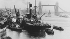
Email: darkwaters@darkwaters.orgDark Waters was originally a 2008 RIBA London exhibition, co-curated with Peter Ackroyd and the Dark Waters Project Group, that considered the rebuilding an ancient relationship with the Thames and an exploration of the nature of the connections that result. A unique Dark Waters Ordnance Survey Map was commissioned for the exhibition, which was part of the London Festival of Architecture. During the exhibition six piers along the Thames were selected for audiovisual installations that linked Londoners with the Thames allowed them to experience the waters on an emotional and immersive level.
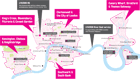
The Thames Clippers riverboat service formed part of the Dark Waters experience connecting the six piers with the five London Festival of Architecture hubs of activity, allowing visitors to travel between events and exhibitions by boat.
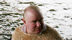
Visit the interviews section of the website to listen to contemporary opinions about the River Thames from experts including those who live on the river.
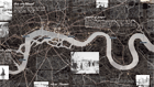
Dark Waters map

To zoom in and out, select the "+" and "-" buttons on the map. The map is draggable, and the top-left panel shows which piece of the complete map you are viewing. View a larger version of this map.